


Ward County
TSHA
USGenWeb >> TXGenWeb >> Ward County >> Ward County, Texas
Glenn Justice and John Leffler
 |
|
|
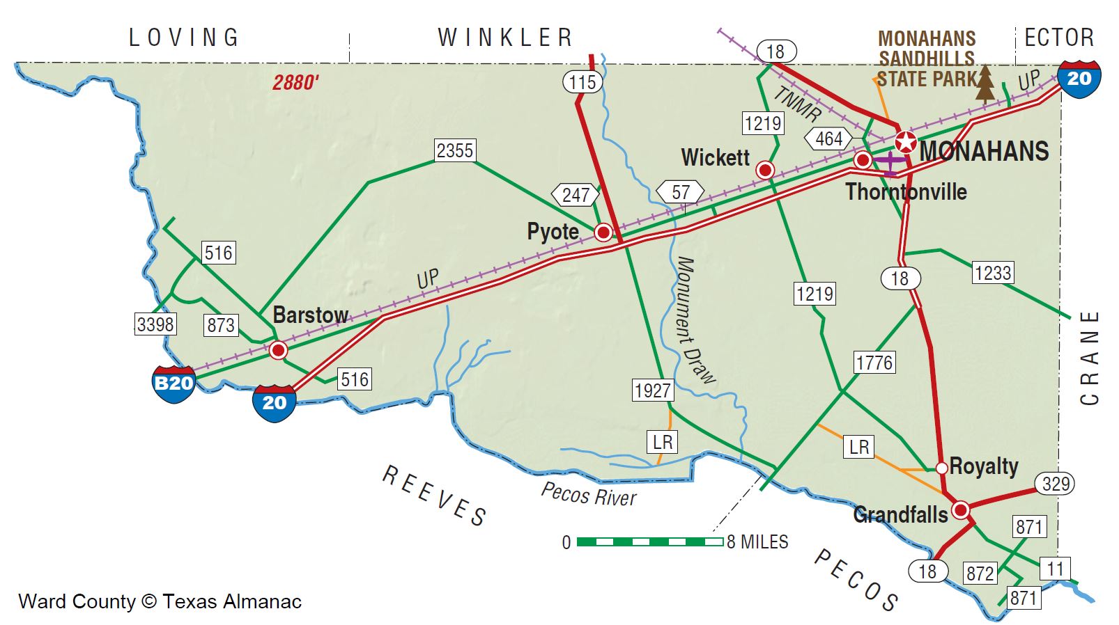
Ward County is on the southwestern edge of the High Plains region of southwest Texas. The center of the county is at 31°32' north latitude and 103°07' west longitude, near the community of Pyote. Monahans, the county seat, is in the northeastern corner of Ward County at the intersection of Interstate Highway 20 and Farm Road 18, thirty-three miles southwest of Odessa on the Missouri Pacific Railroad. The area was named for Thomas W. Ward. Ward County covers 539,460 acres, or 836 square miles, of generally level land; elevations range from 2,400 to 2,800 feet above sea level. Large areas in north Ward County are composed of active, windblown sand dunes, subject to wind erosion and sediment transport. This area has scattered oak groves and a number of sections commonly barren except for grasses and nongrassy herbs, the abundance of which depends on rainfall. Along the Pecos River in the south and west are areas of alluvial fans composed of sand, gravel, and mud substrate. Scrub brush and sparse grasses grow in this part of the county. Near the towns of Grandfalls and Royalty are areas of caliche with bedrock and alluvial material in the substrate. Scrub brush, sparse grasses, creosote bush, and cacti grow in the shallow, stony soils. Less than 1 percent of Ward County is considered prime farmland. The Pecos River is the only continuous flowing source of surface water in the area; the average annual rainfall is twelve inches. Temperatures in Ward County range from an average low of 29° F in January to an average high of 98° F in July. The average growing season lasts 223 days. The production of petroleum and natural gas are quite important to the economy.
Archeological investigations conducted in northwestern Ward County have found evidence of prehistoric man in the form of occupational debris, petroglyphs, and pictographs. Historic Indian groups that may have successively occupied or annually traveled through what is now Ward County include the Jumanos, the Apaches, and the Comanches. Information concerning these Indians can be found in journals written by early Spanish explorers, including Álvar Núñez Cabeza de Vaca and Antonio de Espejo. Although Cabeza de Vaca did not describe any particular Indians in or around the area that is now Ward County, he did mention "the cow nation" that may have ranged over the area. These bison hunters were probably the same group that Espejo, leader of a Spanish expedition through West Texas in 1583, called the Jumanos. The sand dunes east of the site of present Monahans are claimed to have been an annual watering spot for Comanches. Water is available at shallow depths in the sand hills, a critical factor in attracting human populations to the area. Large numbers of artifacts, including projectile points, beads, and scrapers, and various other stone tools have been found in the sand hills. The Emigrant Road, routed on a survey conducted in 1849 by Randolph B. Marcy, passed from Dona Ana to Preston and skirted the southern part of what is now Ward County. The Butterfield Overland Mail used Emigrant's Crossing of the Pecos River. In 1881 the Texas and Pacific Railway crossed the region and established stations at Sand Hills, Monahans, Aroya, Pyote, Quito, Quito Quarry, and Barstow. The Texas state legislature carved Ward County from a portion of Tom Green County in 1887, but by 1890 only seventy-five people lived there. The county was organized in 1892, and Barstow became the county seat; a red sandstone courthouse was built in 1893. By 1900 the United States Agricultural Census found 167 farms and ranches, encompassing 424,000 acres, in the area, but only 5,500 acres were described as "improved." The economy revolved primarily around ranching at that time. Almost 13,000 cattle and about 4,400 sheep were reported in the county that year, while only eighty-three acres were planted in corn and 1,500 acres in cotton. The census reported 1,451 people that year. By 1904 Barstow had become a farming and ranching trade center located near numerous vineyards and orchards made possible by irrigation projects on the Pecos River. In 1904, however, an earthen dam on the Pecos burst, and the resulting flood waters salted and ruined many of the farms near Barstow. A serious drought plagued farmers in 1907; nevertheless, by 1910 there were 231 farms and ranches, and 2,389 people lived there. Almost 14,000 cattle were reported that year, and 3,000 acres were planted in cotton. There was another drought in 1910, and the vineyards and orchards began to decline by 1911; farming along the Pecos had ceased by 1918. Cotton production expanded in the county during the 1910s, however, and by 1920 more than 10,000 acres were devoted to the fiber. That year there were 238 farms and ranches, and the population had increased slightly to reach 2,615.
In the 1920s Ward County entered a period of economic prosperity following the opening of the Hendrick oilfield in 1926. Pipelines and railroad loading tanks were constructed at Wickett, Pyote, and Monahans. Oil was discovered at Grandfalls in 1929, and the nearby community of Royalty was established. That same year the Texas and New Mexico Railroad built tracks from the New Mexico state line to Monahans to handle the increasing transportation demands of the oil industry. Cotton production fell off during this period; by 1930 fewer than 9,000 acres were planted in cotton, and the number of farms in the area had dropped to 209. Oilfield activity was responsible for a large population increase during the 1920s, and by 1930 there 4,599 people living there. The 1930s were boom years in Ward County. U.S. Highway 80 was paved from Big Spring to Pecos by 1933. Oil, gas, potash, and sodium sulfate industries developed, and Monahans became the economic and population center of the county. A refinery was built at Wickett, and Monahans had carbon black and chemical plants by 1937; almost 9,720,000 barrels of crude oil were produced in the county in 1938. On May 10, 1938, Monahans won a contested election to move the county seat from Barstow to Monahans. The election was upheld in 1939, and the county seat moved to Monahans that year. The population of Ward County more than doubled during the 1930s, rising to 9,575 by 1940. Pyote experienced a period of economic prosperity during World War II, after the Pyote Army Air Field was constructed in 1942. Meanwhile, oil remained important to the local economy throughout the 1940s, though production declined somewhat; more than 6,873,000 barrels were produced in the county in 1944, and 6,074,000 barrels were produced in 1948. By 1950 the county's population had increased to 13,346. Oil production expanded during the 1950s. Over 11,430,000 barrels were produced in 1956, and 22,235,000 barrels were produced in 1960. The county also benefitted in 1957 from the opening of the 3,840-acre Monahans Sandhills State Historic Park (located northeast of Monahans), which attracted tourist dollars to the local economy. By 1960 the county's population had increased to 14,917. Oil production continued to increase in the early 1960s but then dropped off sharply. More than 28,245,000 barrels were produced in 1965, but by 1968 production had dropped to 15,172,000 barrels. As a result, the population declined to 13,019 by 1970. Ward County grew to 13,976 residents in 1980, reflecting a period of increased oilfield activity. In 1982, 88 percent of the land was in farms and ranches, but less than 1 percent of the land was cultivated; almost 97 percent of the agricultural receipts were derived from livestock, especially cattle and hogs. That year 122,243,000,000 cubic feet of gas-well gas, 18,742,000,000 cubic feet of casinghead gas, and more than 8,707,000 barrels of petroleum were produced in Ward County. By January 1, 1991, 668,715,000 barrels of oil had been produced in the county since 1928.
The voters of Ward County supported the Democratic candidates in
every presidential election between 1892 and 1968, with the
exception of 1952 and 1956. Republicans carried the county from
1972 to 1992. In 2014 there were 11,625 people living in the
county. About 43.4 percent were Anglo, 4.9 percent African
American, and 50.4 percent Hispanic. Most residents lived in
Monahans (population, 7,569). Other communities that year
included Barstow (370), Grandfalls (393), Pyote (122), Royalty,
Thorntonville (514), and Wickett (525). Monahans hosts a number
of annual events, including the Freedom Fair, the Greenthumb
Show, the Miss Monahans Pageant, and the AQHA Quarterhorse Show,
all held in July; a Pecan Perfection show is held there in
November, and a Christmas Parade is staged each December.
BIBLIOGRAPHY: Texas Permian Historical Society, Water, Oil, Sand and Sky: A History of Ward County (Monahans, Texas, Junior Chamber of Commerce, 1962). Ward County Historical Commission, Ward County. (Dallas: Taylor, 1980?).
Handbook of Texas Online, Glenn Justice and John Leffler, “WARD COUNTY”