


Ector County
TSHA
USGenWeb >> TXGenWeb >> Reeves County >> Reeves County, Texas
Julia Cauble Smith
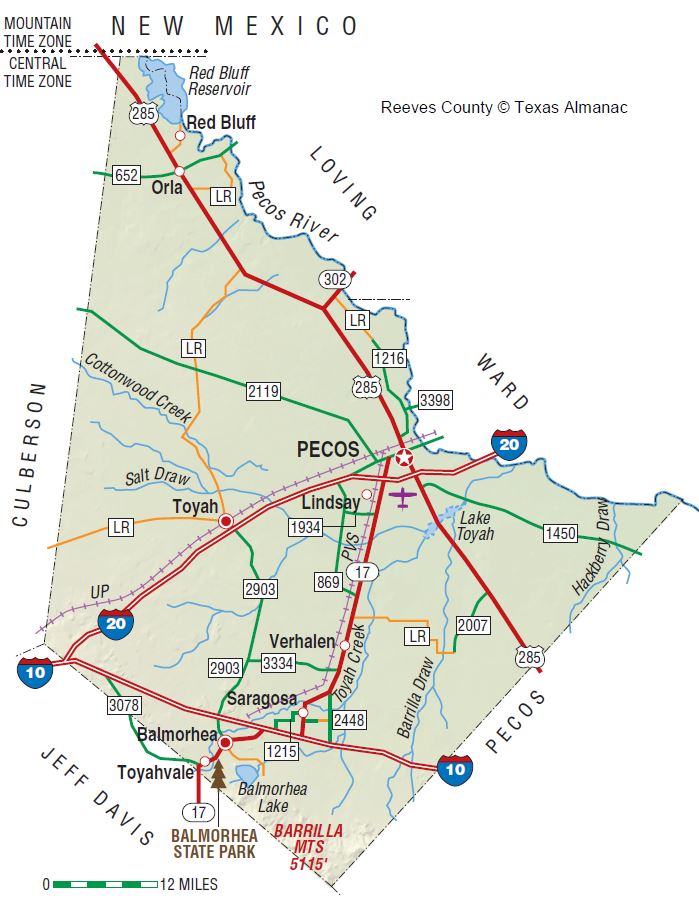
Reeves County is on Interstate Highway 20 in the Trans-Pecos region of West Texas with the northern edge of its irregular shape touching New Mexico. On the northeast it borders the Pecos River, which separates it from Loving and Ward counties. It is bounded on the southeast by Pecos County, on the southwest by Jeff Davis County, and on the west by Culberson County. Pecos, the county seat, is seventy-four miles southwest of Odessa. The center of the county lies at 31°20' north latitude and 103°40' west longitude. Reeves County comprises 2,626 square miles of land with flat and undulating terrain in its northern part and mountainous topography in the extreme south. Altitudes, including those in the Davis Mountains, vary from 2,538 to 4,210 feet above sea level. The Barrilla Hills rise abruptly with steep slopes to a height of 150 to 200 feet above the surrounding plain. About 85 percent of the county is covered by a broad gently-sloping plain topped by outwash material from the mountains. Surface geology is mostly Quaternary, except for the extreme southeastern corner, which is Igneous, and the western and eastern edges, which are Cretaceous. Soils are light reddish-brown to brown sands, clay loams, clays, and rough stony lands. The average annual temperature is 64° F. The growing season extends 226 days. Rainfall, which averages ten inches per year, runs into several intermittent lakes in the west central area of the county. These shallow playas fill with water after downpours, but shrink and sometimes disappear through evaporation between rains. Toyah Lake is the largest playa in the county, with walls formed by cliffs of ten to forty feet in height. The entire county is drained by the Pecos River. The main tributaries are Salt and Toyah creeks and Four Mile, Horsehead, and Salt draws. Two lakes provide water for recreation and irrigation: Red Bluff Reservoir on the Pecos River in extreme northwestern Reeves County and Balmorhea Lake in the southwest. Vegetation consists of sparse grasses, scrub brush, creosotebush, cacti, oak, juniper, and mesquite, which provides the area's only timber. Natural resources include gypsum, limestone, salt, oil, gas, and volcanic ash. Other minerals include brine, sand, gravel, and recovered sulphur. Less than 1 percent of the land is considered prime farmland.
The first people to inhabit Reeves County lived in the rock shelters and caves around the edge of the Barrilla Hills and built permanent camps near Phantom Lake, San Solomon Spring, and Toyah Creek. These prehistoric people left behind artifacts and pictographs as evidence of their presence. The Jumano Indians irrigated crops of corn and peaches from San Solomon Spring, where Balmorhea State Recreation Area is now located. Three Jumanos met the expedition of Antonio de Espejo near Toyah Lake in 1583, and guided explorers to La Junta by a better route. Settlers of Mexican descent farmed in the county's Madera Valley from early times. In 1849 John S. Ford traveled along Toyah Creek and noted the productive land upon which the Mescalero Indians cultivated corn. Farmers of Mexican descent who irrigated from San Solomon Spring in the last half of the nineteenth century found a lucrative market for grains, vegetables, and beef at Fort Davis. The first Anglo farmers arrived in Toyah Valley in 1871, when George B. and Robert E. Lyle began irrigating crops from Toyah Creek. Open range ranching first attracted White settlers to the Davis Mountains in 1875.
By 1881 the Texas and Pacific Railway built tracks through Reeves County. At that time section houses were constructed at Pecos and Toyah, which opened a post office that year and later became a shipping point for local ranchers. Pecos was named the seat of government when Reeves County was separated from Pecos County in 1883 and organized in 1884. Pecos constructed a three-room school in 1883 and opened a post office in 1884. The county was named for Confederate colonel George R. Reeves. The name of the first community was Saragosa, which opened a post office in 1884. The name was changed to Lyles in 1891 and to Toyahvale in 1894. By 1885, when several ranchers herded cattle on the northern range of the county, Pecos reported 150 residents and Toyah had sixty. By 1890 the county population had expanded to 1,247, including seven African Americans, fifteen Chinese, and 351 foreign-born residents. In that year a second railroad, the Pecos River, constructed fifty-four miles of tracks from Pecos to the New Mexico line along the river, providing transportation for local agricultural products. In 1894 a post office was established at Brogado, nine miles southeast of Pecos, and Toyah built its first school. By 1899 Toyahvale had a public school district with three schools, and during the 1899–1900 school term the Pecos school had 111 students and three teachers. A second school was added for the 1900–01 term with 148 pupils and four teachers. A second community called Saragosa, located in the southernmost part of the county, was designated a post office in 1900. In that year the census reported a total of 1,847 county residents, including 474 foreign-born, twelve African Americans, and ten Chinese. In 1902 Toyah organized its first church. Reeves County reported five manufacturing establishments that employed sixteen workers at wages totalling $8,835 and made products worth $30,085 in 1900. Manufacturers increased to nine by 1920, with sixty-two employees earning just over $88,000 and producing $187,000 worth of goods. From 1940 to 1967 the number of manufacturers grew from five to seventeen, but that number declined to eleven in 1982. The values of production over those years increased from $165,807 in 1940 to $3.6 million by 1977, but manufacturing remained secondary to agriculture and petroleum in the county economy.
The census of 1900 showed sixty-three farms countywide, of which forty-one were operated by owners and twenty-two by tenants. Farms comprised nearly 900,000 acres and had 51,000 cattle. In that year the agricultural economy of Reeves County was affected when the state ended free use of its land. Agents were sent across West Texas to collect rents from ranchers on public land. Between 1901 and 1905, however, state law permitted sale of school lands in West Texas, allowing individuals to purchase four sections of land on generous credit terms. Reeves and other West Texas counties experienced a rush of new settlers, which continued even after the law was changed in 1905 to award land to the highest bidder. Between 1903 and 1913 several new communities developed, but most were ephemeral. Both Alamo, renamed Pera in 1905, and Dixieland opened post offices in 1903. Other towns receiving post offices included Panama in 1904, Orla in 1906, and Hermosa and Arno in 1907. Balmorhea began operation of both a school and a post office in 1908, and post offices were organized in 1910 at Pyle, Mont Clair, and Angeles; the latter moved to Orla some time later. Hoban received a post office in 1911 and Crystal Water in 1913. By the 1990s, however, only the post offices at Orla and Balmorhea were still in existence. The 1910 census reflects the effects of the school-land rush after 1901, showing the population more than doubled in a decade to 4,392, including 408 foreign-born, thirteen Chinese, and eighty-two African American residents. Though the value of farms in the same period doubled to reach $4.4 million, only twelve bales of cotton and small grain crops were harvested on more than 15,000 acres of farmland, as most Reeves County farmers continued to operate subsistence farms. Although the number of farms climbed to 225, and most were owner-operated, improved acres dropped below 600,000. Cattle herds were reduced to less than 7,000 head, and only milk cows and chickens increased in numbers.
In 1911 the Pecos Valley Southern Railway completed tracks from Pecos to Toyahvale, allowing improved transportation of agricultural products. A drought swept across the county in 1916, however, and many families who had come during the school-land rush gave up their farms and moved away. By 1920 the population had grown only slightly to 4,457, including seventeen African Americans, four Chinese, and 666 foreign-born residents. While farms decreased to only 206, operated by 140 owners and sixty-six tenants, farm value increased to $7.1 million. Numbers of range cattle increased to nearly 37,000, and sheep climbed to almost 2,500. Over 16,000 acres was farmed, and 1,846 bales of cotton and 16,000 tons of hay led production of a wide variety of grain and vegetable crops. In the early 1920s Pecos became the focus of Delaware Basin oil exploration and received substantial publicity, though little oil and gas were found in paying quantities. By 1930, however, oil excitement had brought a larger and more diversified population to the county. Of a total of 6,407 residents, 178 were African American and fifty-six foreign-born from fifteen countries.
Reeves County felt the impact of the Great Depression and the earlier drought, as cultivation of crops continued to decline into the 1930s. In 1930 the number of farms had risen slightly to 327, but farm tenancy increased. Only 114 farms were operated by owners, and 213 by tenants. Cotton remained a strong crop with 3,200 bales harvested, and over 7,000 tons of forage was produced on nearly 3,000 acres. Overall numbers of livestock decreased, and the value of livestock fell to half of its earlier total, though cattle numbers remained at nearly 24,000 head. By 1940 the county population climbed to 8,006. Farms fell to 277, and tenant farmers continued to outnumber owners. Livestock production, valued at over $1 million, dominated agriculture, with only $376,031 produced by crops. By 1950 the population increased sharply to 11,745, including 280 non-White residents. Educational levels in that year were reflected by 1,015 high school and 415 college graduates in the county's population. The Toyah field, a gas-producing area, was discovered in 1952, and the Geraldine-Ford field began production in 1956. Although neither field was a giant, both added to the economy of the county. In the 1950s crop values soared to $224 million, overtaking livestock production, which climbed to $2.5 million. By 1954 a total of 322 farms operated on 1.5 million acres, of which 81,000 was devoted to cropland. By 1959, however, agriculture had declined, and the number of farms dipped to 261. Livestock values fell to $2.48 million and crops to $19 million. In 1960 the Reeves County population reached an all-time high of 17,644, including 634 non-White residents. High school graduates represented 9 percent of the residents, and 669 were college graduates. The value of livestock rose over the decade, reaching $12 million by 1969, but the number of farms declined to only 231 in that year, with only 26 percent of operators living on their farms. By 1970 the population dropped to 16,526. High school graduates climbed to 37 percent, and college graduates included 5.5 percent of the population. In the 1970s Reeves County witnessed the development of three oilfields that added significantly to its economy: the Athens, Chapman Deep, and San Martine fields. Between 1939 and 1973 the county produced 37 million barrels of oil. The value of livestock soared to $83 million by 1978 but dropped to $68 million in 1982, by which time the number of farms had fallen to 149, and 34 percent of owners lived on their land.
Although by 1980 West Texas experienced a dramatic oil boom with greatly-increased drilling activity and an influx of new people to fill blue collar jobs, the population of Reeves County fell to 15,801 in that year, of which 3 percent were African American and 62 percent were Hispanic. In 1982 the county ranked twenty-seventh in the nation in highest percent of residents of Spanish origin. High school graduates increased to nearly 45 percent of the population, and college graduates to about 9 percent. As the 1980s continued, the oil industry declined due to the falling price of crude oil. Primary crops in the decade included barley, along with cotton, hay, and wheat; farmers also raised significant numbers of onions, bell peppers, peaches, and pecans. Business establishments in the county numbered 341, and most workers were employed in tourism, oil and gas extraction, sulfur mining, cottonseed oil mills, or agribusiness. By 1990 the population was 15,852, of which 347 were African American, thirty-six Native American, thirty-six Asian, and 11,545 Hispanic. The county was served by two school districts, consisting of seven elementary, two junior high, two senior high, and one ungraded school. Thirty-seven churches reported a combined membership of nearly 12,000. The largest denominations were Catholic and Southern Baptist. In the early 1990s the Reeves County economy continued to be based on oil and agriculture, supplemented by tourism. As of 2014, 14,349 people lived in the county. About 19.2 percent were Anglo, 5.4 percent African American, and 74.5 percent. Incorporated cities included Balmorhea (population, 504), Pecos (8,870); and Toyah (92); unincorporated communities included Brogado, Orla (80), Red Bluff, Saragosa (185), Toyahvale (60), and Verhalen. The county faced problems of declining oil prices and crude reserves. Overgrazing, which occurred when its arid pasturelands were first pioneered, had improved under management, and reduction in irrigated agriculture and the use of underground water supplies had improved the level and availability of water. Prospects for the future included a fluctuating population, higher levels of high school education, and continued support for Democratic party candidates. In the presidential election of 1888 residents of Reeves County had given Democratic candidate Grover Cleveland 308 votes and Republican candidate Benjamin Harrison only fourteen. Voting for the Democratic party became a trend that continued through the 1948 election. However, when the nation voted the Republican war hero Dwight D. Eisenhower into the presidency in the 1950s, Reeves County twice gave him a majority. By 1960 voters returned to the Democratic column, giving an edge of almost 700 votes to Democrat John F. Kennedy. Fellow Texan and Democrat Lyndon B. Johnson won the county by a 2-to-1 lead in 1964, and the Democrats took the county again in 1968. The Democratic party swayed too far to the left for residents in 1972, however, and a majority of county voters supported Republican Richard M. Nixon. Thereafter, the county voted Democratic from 1976 until 1992, when Bill Clinton received 2,569 votes, George Bush 1,244, and Ross Perot 734. Reeves County is noted for its West of the Pecos Museum at Pecos and for Balmorhea State Recreation Area and Lake. The county celebrates a Rodeo Week, June Fest, Golden Girl of the West Pageant, Night in Old Pecos, and an 1800s Parade at Pecos in June; a Fourth of July Parade, Old Fiddlers Contest, and West of the Pecos Rodeo at Pecos in July; a Frijole Cookoff at Balmorhea and cantaloupe festival in August; and Fall Fair Festival at Pecos in October.
BIBLIOGRAPHY: Alton Hughes, Pecos: A History of the Pioneer West (Seagraves, Texas: Pioneer, 1978). Susan D. Navarro, "Creation of Reeves County," Permian Historical Annual 8 (1968). Frederick W. Rathjen, The Texas Panhandle Frontier (Austin: University of Texas Press, 1973). Toyah Historic and Centennial Committee, Toyah Taproots: A Memory Book of Those Who Put Down Their Roots in Toyah (Austin: Nortex Press, 1984).
Handbook of Texas Online, Julia Cauble Smith, “REEVES COUNTY”