Welcome
 |
|
Reeves |
Welcome to Reeves County. You will be seeing some major changes to the site in the near future. I plan to be adding as much new content as possible. If you have any information you would like to have added, please feel free to let me know and I will try to locate a resource or if you have information you would like to donate, we can get that published for you. Please feel free to reach out with any questions you may have.
Submissions
We accept any kind of record that reflects the history of the area or contains information
on its inhabitants. We are especially interested in transcriptions of original records like (but not limited
to) marriage, birth and death indexes, marriage, birth and death certificates, land records, military records,
Family Bible records, census records, wills and their probates, or lists of cemetery burials. We would love
to include your information on this site whether it contains information on one person or a thousand. If you
have something of interest, please contact me.
TSHA:
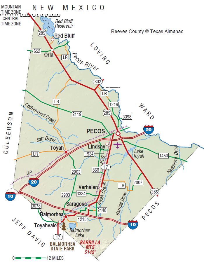
Reeves County is on Interstate Highway 20 in the Trans-Pecos region of West Texas with the northern edge of its irregular shape touching New Mexico. On the northeast it borders the Pecos River, which separates it from Loving and Ward counties. It is bounded on the southeast by Pecos County, on the southwest by Jeff Davis County, and on the west by Culberson County. Pecos, the county seat, is seventy-four miles southwest of Odessa. The center of the county lies at 31°20' north latitude and 103°40' west longitude. Reeves County comprises 2,626 square miles of land with flat and undulating terrain in its northern part and mountainous topography in the extreme south. Altitudes, including those in the Davis Mountains, vary from 2,538 to 4,210 feet above sea level. The Barrilla Hills rise abruptly with steep slopes to a height of 150 to 200 feet above the surrounding plain. About 85 percent of the county is covered by a broad gently-sloping plain topped by outwash material from the mountains. Surface geology is mostly Quaternary, except for the extreme southeastern corner, which is Igneous, and the western and eastern edges, which are Cretaceous. Soils are light reddish-brown to brown sands, clay loams, clays, and rough stony lands. The average annual temperature is 64° F. The growing season extends 226 days. Rainfall, which averages ten inches per year, runs into several intermittent lakes in the west central area of the county. These shallow playas fill with water after downpours, but shrink and sometimes disappear through evaporation between rains. Toyah Lake is the largest playa in the county, with walls formed by cliffs of ten to forty feet in height. The entire county is drained by the Pecos River. The main tributaries are Salt and Toyah creeks and Four Mile, Horsehead, and Salt draws. Two lakes provide water for recreation and irrigation: Red Bluff Reservoir on the Pecos River in extreme northwestern Reeves County and Balmorhea Lake in the southwest. Vegetation consists of sparse grasses, scrub brush, creosotebush, cacti, oak, juniper, and mesquite, which provides the area's only timber. Natural resources include gypsum, limestone, salt, oil, gas, and volcanic ash. Other minerals include brine, sand, gravel, and recovered sulphur. Less than 1 percent of the land is considered prime farmland.
.... Read More: TSHA ...


