

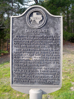
Caddo Trace
Directions: SH 49/11 east of Daingerfield about 3 mi. across from entrance to Daingerfield State Park
Marker #: 5343007842
Year Dedicated: 1967
Size, type: 18" x 28"
Last reported condition: Poor; Refinish
Caddo Trace
Hunting and trade route for area between Arkansas and Red Rivers; used by Caddo Indians, who occupied the northeast corner of Texas and adjacent states. Like many Indian trails, it was later usurped by whites; after 1840, it became part of stage and mail routes. Teamsters used it transporting goods to market; soldiers marched along it to and from several wars. The trace follows or crosses in places 3 other early trails: Cherokee, Choctaw, and Trammel's. Today state highways 11 and 49 (Hughes Springs to Daingerfield) follow the same general route.
Coordinates:
Decimal degrees: N 33.012615 W -94.685540
Degrees, minutes: N 33 00.757 W 094 41.132
UTM: Zone 15, Easting 342557, Northing 3653947